|
|
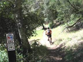
Features: Pine/Oak woodland, Noble Creek mines and mining artifacts, rugged descent. Length: 10 miles (one way). Elevation gain/loss: -2,400'. Hiking time: 5 hours (downhill). Users: Hikers, bikers, equestrians. Difficulty: Hard. Best time of year: Any time except during storms. Potable water: At eastern trailhead. Access points: Eastern trailhead at Penny Pines parking area along Sunrise Highway, western trailhead off Pine Creek Road in Pine Valley. Description: Noble Canyon is a world-renowned trail for mountain biking enthusiasts. It is not recommended to hike this trail from Pine Valley to the top, because of the length and extreme elevation gain. This description discusses trail descent from the top. The Noble Canyon National Scenic Trail begins about 1/10th of a mile from the Penny Pines parking area near the 27.3 mile marker on Sunrise Highway. Hike west from the parking area past a water sigot/tank to the intersection with the Big Laguna Trail. Continue straight (west). It runs initially through pine and oak woodlands with a couple of ascents, until Filaree Flat becomes visible far below. Mt. San Jacinto and Mt. San Gorgonio can be seen shimmering to the north, often covered with snow. The trail begins to descend, crossing Deer Park Road and Noble Creek in several places, and then climbs around a chaparral ridge covered with white ceonothus in the spring. Descending again, the trail passes through a grassy area sporting abundant wildflowers in the spring and early summer. At about 3 miles, the trail approaches Noble Creek and parallels it through pines, black oaks and live oaks until it emerges in a wider sunlit section of the canyon. The trail passes through shady water courses and riparian areas which offer magnificent colors in the fall, and cool shady resting spots in summer. Remains of an old gold mine, active in the 1880s, and foundations of two old cabins are still visible. The trail crosses to the west side of the creek (NOT a water source for hikers unless purified) and switches back the remaining 3 miles to the lower-end trailhead and parking lot. This part of the trail is very exposed, dry and hot in the summer (and sometimes in spring and fall). Carry lots of water! As you approach the tri-fork near the Pine Valley trailhead, take the first wide trail that goes left. It follows a dry creek and eventually winds over a ridge, then down to the trailhead. (Note: the third trail on the right leads to Pine Creek Road). If you are in the majority that have arranged a car shuttle for this hike, the west Noble Canyon Trailhead is located 1.2 miles N of Pine Valley on Old Highway 80, then 1.6 miles NE on Pine Creek Road and 0.2 miles on a spur to the parking lot. It is important to note trail etiquette on this trail because of the heavy use of mountain bikes hurtling downhill amidst hiking and equestrian traffic. Hikers yield to equestrians, and bikers yield to hikers AND equestrians. |
|
|