|
 Features: Intermittent stream crossing, link to Cuyamaca State Park.
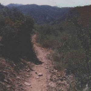
Length: 4 miles one way, from Noble Canyon Trail to the State Park boundary. Elevation gain/loss: -650'. Hiking time: 2 hours. Users: Hikers, equestrians, mountain bikes. Difficulty: Hard. Best time of year: Any time except during storms. Potable water: None. Access points: Noble Canyon Trail, Pioneer Mail picnic area. Description: Indian Creek Trail leads from the Noble Canyon Trail several miles from the Penny Pines trailhead, intersects with the Pine Mountain trail, and continues westerly to the boundary of Cuyamaca State Park. This is a delightful "linker" trail, that provides a great way to put several interesting and relatively long loop hikes together. Starting at Penny Pines, follow the Noble Canyon Trail for 2.4 miles, then turn right onto Indian Creek Trail. Descend west through pines, oaks and high chaparral almost one mile. Here, the broad, shallow Indian Creek Canyon comes into view. Indian Creek carries a bit of water most of the year, and small herds of cattle graze in the tall grasses of the meadow during the summer. After the trail crosses the creek, it ascends 1 mile across an east-facing slope devoid of trees to arrive at Champagne Pass, which marks the halfway point. At 0.10 mi further, the trail intersects the Pine Mountain Trail.You now have three options for your return trip. |
|
|