|
|
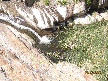
Features: Intermittent stream, waterfalls. Length: 1.8 miles round-trip. Elevation gain/loss: -466'/+466'. Hiking time: 1 hour. Users: Due to the steepness of the initial descent, horses are not recommended. Difficulty: Moderate. Best time of year: Year-round. Falls are much more voluminous after spring snow-melt. Potable water: None. Access point: Sunrise Highway across from the 15.5 Mile Marker at the northern end of the guardrail. Plenty of parking in large turnout. Description: A steep descent to an old easement road under power lines, and continues downward to an oak wooded area where the trail splits. Stay to the left trail, and begin climbing up the canyon to the falls. NOTE: This trail is not managed as a Forest Service Trail. It is neither marked nor maintained. |
|
|